


Mt. Fuji & Sabo Project
Front Page>
Mt. Fuji & Sabo Project >
Further Study >
Techinical Data
Techinical Data
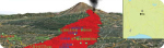
Lava Flow 3 Dimensional Map & Simulation
We have created the "Mt. Fuji lava flow three-dimensional map" to easily find out about the reach range of lava flowed.
Red Relief Image Map around Mt. Fuji
This is a red relief image map computed with the data by the airplane laser measurement.