


Yui Landslide Control Project
Front Page>
Yui Landslide Control Project >
History >
History of Disasters

History of Disasters
In Yui district, Shimizu City Shizuoka Prefecture, regidents and tourists had suffered from sediment-related disasters and landslides in many times.
Twenty-six disasters are in the records, but much more disasters due to earthquakes had occurred here.
Recently, there were Terao landslide and Tanabata torrential rain disaster, etc.
Twenty-six disasters are in the records, but much more disasters due to earthquakes had occurred here.
Recently, there were Terao landslide and Tanabata torrential rain disaster, etc.
History of Disasters around Yui Area
| No | Year | Factor | Disaster | Location | Summary |
| 1662 | earthquake | collapse | Mt. Satta collapsed and Satta pass was closed for a year and 2 months. | ||
| August 1699 | typhoon | high surf | Machiyahara, Kitada, Imajuku | A high surf wiped out three villages. | |
| October 1707 | earthquake | collapse | A big earthquake. Satta pass collapsed. | ||
| August 1730 | earthquake | high surf | A high surf washed out three villages. | ||
| November 1854 | earthquake | collapse | Afterquakes continued for 15 days. Almost all hoses collapsed. Many casualties reported. Some slope failures occurred. Ground deformations, stone wall collapses, high surf. (Satta pass collapsed. A seaside uplifting occurred) |
||
| 1 | June 1859 | heavy rain | collapse | Terao, Nishikurasawa | It began to rain on June 10th, and became heavy rain on June 23rd. Some slope failures occurred on June 25th. Many bridges washed away. Two areas of the west side of Terao Osawa River were buried. A slope failure hit main hall of Hosyaku Temple at Nishikurawsawa, and the priest's quarters was buried. Houses complete collapsed:17 Houses half collapsed:16 |
| 2 | May 1868 | heavy rain | collapse | terao, Nishikura | Rainfall continued for a month form April 22nd. A makeshift hall of Hosyaku Temple and 11 houses were buried by a slope failure. |
| 3 | August 1910 | typhoon | landslide | Saisanji-sakanoue, Kubota | Continual rain and bad ground conditions (soften and fissures nearly 41 hectares), and 20 households evacuated and moved. (Four-day precipitation of Shizuoka Prefecture was 679mm) |
| September 1917 | rainstorm | high surf | Yui Town | After 11 PM, Rainstorms hit and high surfs pounded beaches, destroyed the railway on the next day. Many houses washed away, and many fishing boats outflowed. Number of fatalities:2 Number of injured:7 Houses complete collapsed:17 Houses half collapsed:16 Houses outflowed:39 |
|
| October 1918 | rainstorm | high surf | Yui Town | A high surf hit again. | |
| 4 | August 1922 | typhoon | sedement outflow | Kurasawa, Imajuku National Route | A rainstorm hit and the railway of the west side at Yui Station was buried with sediments. And also national route was closed at Kurasawa and Imajuku area by mountain collapses. |
| 5 | July 1923 | seasonal rain front | sedement outflow | Nishikurasawa River | Large sediments flooded out by heavy rain. Sediments covered the railway at the west side of Yui Station, and trains were suspended. |
| September 1923 | earthquake | landslide | Saisanji, Terao | Great Kanto Earthquake occurred. Landslides observed at Saisanji and Terao area. | |
| 6 | September 1924 | typhoon | sedement outflow | Nigorisawa, etc. | Heavy rain and flood. Piers broke at the west bank of Yui River and Wase River, and bridges lost. 6 freight cars was buried. |
| August 1935 | rainstorm | high surf | A big surf hit and broke the Kikukawa railway bridge at Imasyuku. The railway operation was suspended. | ||
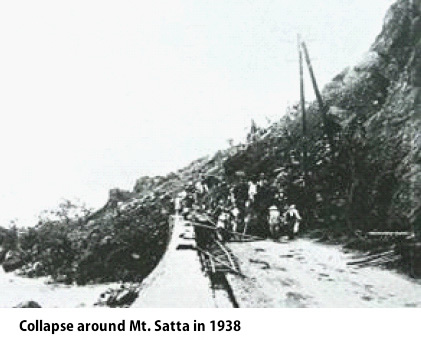
| 7 | July 1938 | frontal rain / typhoon | sedement outflow | Yui Station and periphery | Heavy rain. The national route was buried with sediments and closed. (Eight-day precipitation of Shizuoka Prefecture was 734mm from June 28th to July 5th) |
| 8 | July 1938 | low pressure | collapse | seacoast under Mt. Satta | The slope of Mt. Satta collapsed. The national railway and the national route was buried over 50m. |
| 9 | July 1941 | seasonal rain front / low pressure | collapse | Terao | Mt. Terao collapsed by heavy rain. Houses outflowed: 2 Number of fatalities:6 Number of injured:10 (Two-day precipitation of Okitsu was 287mm) |
| 10 | June 1948 | seasonal rain front / low pressure | landslide | Nakanosawa | By heavy rain, a landslide occurred at middle area (300m above sea level, 100m of width) of Mt. Terao. Orchards were buried over 20ha. |
| September 1948 | cold front / low pressure | flood | Yui River, Yamashita seaside | Heavy rain and flood. The west bank of Yui River collapsed over 50 to 60m. Houses outflowed: 5 Boats and ships outflowed: 18 National railway and national route was closed at Yamashita beach area. Precipitation: Shizuoka Prefecture:287mm, Numazu:84mm |
|
| 11 | September 1948 | typhoon | sedement outflow | Teraonakanosawa | By the Ione typhoon, sediments flooded at Teraonakanosawa (7,500m3) and trains were suspended for 7 hours. |
| 12 | June 1950 | seasonal rain front / low pressure | landslide | Nakanosawa to Terao | Fissures occurred from Nakanosawa to Teraosawa area. Small collapses occurred frequently. |
| 13 | June 1951 | seasonal rain front / low pressure | landslide | Nigorisawa, Imajuku, Terao | At Nigorisawa, Imajuku and Terao, a large landslide was observed over 6ha area. |
| March 1952 | low pressure | collapse | Yui Town | 20 houses were inundated at Yui Town. Some collapses occurred. Yui Station was inundated and trains were suspended. | |
| June 1952 | typhoon | high surf | Motoyama | From the Dinah typhoon, embankments of at Motoyama of Yui Town collapsed. Number of fatalities:1 Houses outflowed: 3 Amount of damage: 20 million yen |
|
| September 1953 | frontal rain / typhoon | collapse | Yui Town | By the typhoon, 40 houses were inundated at Yui Town. Mountain slope collapses occurred over 15 sites. | |
| 14 | August 1955 | cold front | sedement outflow | Nishikurasawa, Terao, etc. | By heavy rain, flood form Yui River brought big damages. Sediments outflowed to Nishikurasawa, Trao, and Terao bridge. |
| August 1957 | frontal rain / low pressure | collapse | ? | By rain, some collapses occurred. Trains of the national railways were suspended temporarily. | |
| 15 | April 1959 | warm front / low pressure | collapse | Okitsuhora | By rain, some collapses occurred at a cave of Okitsu Town. |
| August 1960 | cold front / typhoon | collapse | Higashiyama | By typhoon and rain, a flood occurred at the culvert 200m west of Terao Bridge, Nakanosawa. Up-trains were suspended temporarily. A cliff failure occurred and a house was half collapsed. |
|
| 16 | March 1961 | frontal rain / low pressure | landslide | Terao | A landslide occurred at Terao and the national railway and the national route were buried. Sediment volume: 1,200,000m3 (The land area moved was 6ha, embankments and water channel were collapsed) |
| 17 | June 1962 | seasonal rain front | landslide | Higashikurasawa | By rain, a landslide occurred at south side of Mt. Ohata of Higashikurasawa, but was small impact. |
| August 1962 | typhoon | flood | Terao | Overflowing occurred at Teraosawa and that closed the road. | |
| 18 | March 1964 | low pressure | landslide | Matsugashita | A landslide occurred at Matsugashita of Yui Town over 30ha areas. They estimated that the landslide was nearly 4000m3. |
| 19 | June 1964 | seasonal rain front | sedement outflow | Terao | By heavy rain, Teraosawa and Nakanosawa flooded. The national railway and the national route was buried. They were closed for 13 hours. |
| June 1966 | typhoon | collapse | Yui Town | By the typhoon No. 4, collapses occurred at three areas of prefectural road and town road. A landslide occurred at Gokaizaka of Knabara Town. Houses inundated: 5 (precipitation in the flat plains: 200mm to 300mm) |
|
| 20 | September 1968 | landslide | Terasawa, Nakanodansawa | A fissure was found at a slope behind a house located between Terasawa and Nakanodansawa. Around October, the fissure expanded. |
|
| 21 | February 1971 | low pressure | landslide | Terao, Nigorisawa | Some landslide activities was observed at Terao and Nigorisawa. |
| 22 | February 1972 | low pressure | landslide | Oowada | The landslide occurred at Owada mountain district hit Imasyuku area, and the national route and the national railway were in crawl operation. (Twenty-four-hour precipitation in Shizuoka Prefecture: 245mm) |
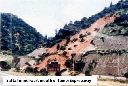
| 23 | June 1972 | heavy rain | collapse | East side mouth of Satta tunnel | By heavy rain, the east mouth of the Satta tunnel (Tomei expressway) was buried. |
| 24 | July 1972 | typhoon | landslide | Imajuku | In Ashigakubo area, the national route and the national railway were in low speed operation due to landslides. |
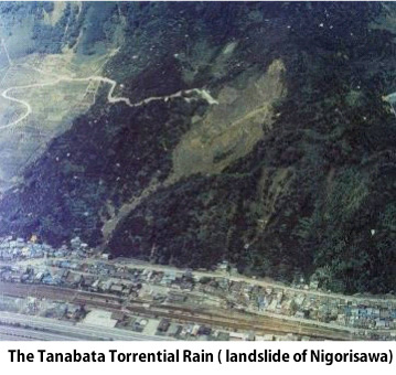
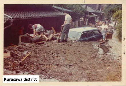
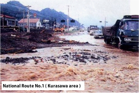
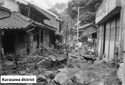
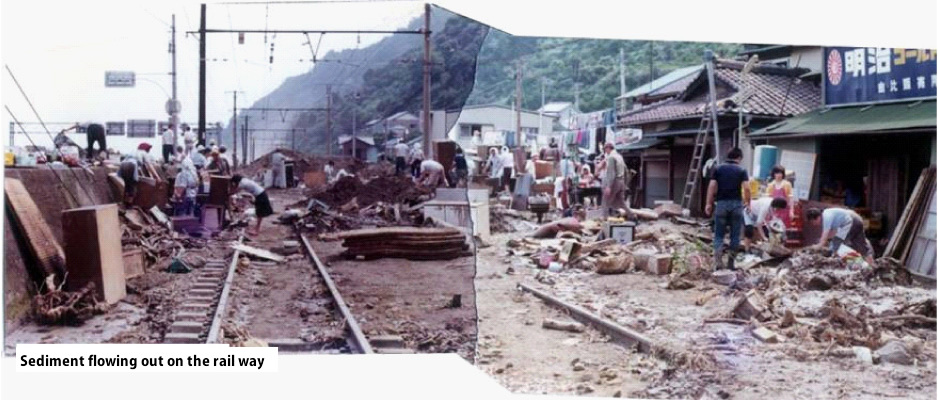
| 25 | July 1974 | seasonal rain front / typhoon | landslide | Terao, Kurasawa | Many collapses, landslides, and debris flows occurred due to the typhoon No. 8 and seasonal rain front. |
| 26 | September 1977 | typhoon | collapse | Satta pass | By the typhoon No. 9, the national route 1 got damaged (slope collapse). |
| [Factors] ■: due to earthquakes ■: due to rain or storm [Disaster] ■: sediment related disaster | |||||
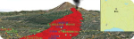
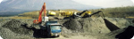
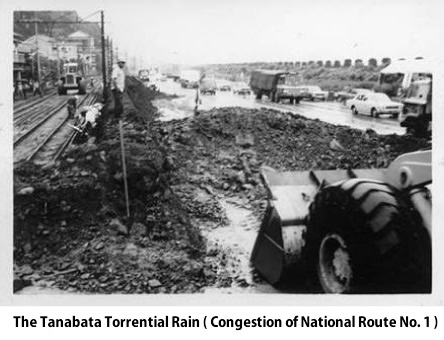
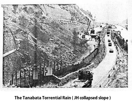
Photos of the Tanabata Torrential Rain
   |
  |
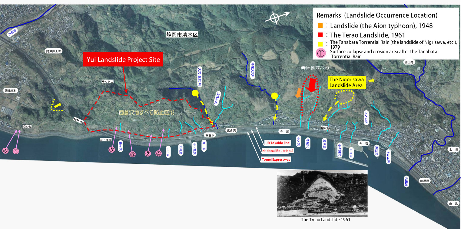
Recent disaster points of around Yui landslide project site
Landslides that affected the transportation network