


Mt. Fuji & Sabo Project
Front Page>
Mt. Fuji & Sabo Project >
Further Study >
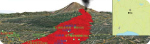
Red Relief Image Map around Mt. Fuji
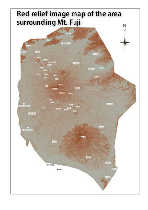
Red Relief Image Map around Mt. Fuji
|
This is a red relief image map computed with the data by the airplane laser measurement. With this technology, the surrounding terrain and the body of Mt. Fuji can be expressed vividly in three dimensions. We can see many lateral volcanoes located at the foot of Mt. Fuji from this red relief image map. There are about 70 lateral volcanoes known. One of them was the crater of a large eruption occurred 300 years ago in the Edo period (1707). Click here or click the left image, and the pdf file will begin to download. |